by Paul Morris.
20th June, 2004: HOW NOT TO GET LOST WITH GPS.
So, you have selected a dive site, consulted a chart, obtained a position, and put it all into the magic little black/grey box called G.P.S. How can you possibly get lost? Allow me to explain.
What do I know about GPS anyway? Well. I’m just a technically minded user that has made some of these mistakes before. Hopefully I can share a few tips to avoid you doing the same.
A quick introduction to GPS.
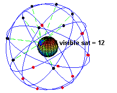 In case you didn’t know, GPS stands for Global Positioning System. It consists of a network of satellites orbiting the earth, each transmitting a radio synchronisation signal. Each satellite knows its own precise position in space at any one time, so when a GPS receiver (the box on the boat) picks up enough of these signals it can calculate its own position, similar to triangulation or how we use transits to pinpoint a wreck.
 Lesson number one: GPS is not magic.
What’s in a number – Positions
As you will hopefully already realise, positions on nautical charts are usually referred to in degrees minutes and seconds e.g. 51 45 55N 02 39 12W However, since 1st January 1999 the Admiralty switched to quoting positions in degrees, minutes and decimals of a minute; the convention for GPS e.g. 51 45.917N 02 39.200W (In case you didn’t realise thats the same position as above!). Many GPS receivers will give positions in either format but take care which you use! It is easy to convert seconds to decimal minutes – simply divide the seconds by 60.
In passing it is worth considering what both 0.010 of a minute and a second (approx 0.017 minutes) represent on the Earth’s surface. One hundredth of a minute is some 18.5 metres in latitude and about 12 metres in longitude in the South of England or some 9 metres in longitude in the North of Scotland. A second is 1/60 of a nautical mile and thus it is about 30 metres in latitude and some 20 metres in longitude in the South of England or some 15 metres in longitude in the North of Scotland.
So, take great care when obtaining your positions. If your position is accurate to one second, irrespective of the accuracy of GPS or your converted position, you will need to search around a square of 30m x 20m to find your site. Wherever possible obtain your positions to three decimal places (i.e. thousandths of a minute). In practice, it may only be feasible to get an accurate position when you have actually entered a mark on your GPS at sea whilst actually on top of a site. However, this will then allow you to find the same site again, subject to the accuracy of GPS (typically <10m) on both the day you recorded it, and the day you try to rediscover the same site! Suddenly transits are starting to look pretty accurate again, right?
Depending on your source of the position, they may not list the format used. The simplistic way to tell is to look through the book taking note of the last two digits of each position and see if they go over 60. If you look at older Admiralty charts or other wreck info resources and the last two digits never go above 60 then they are most likely quoted in degrees-minutes-seconds and will need to be converted. Otherwise, you will find yourself in the wrong area. An error here could put you nearly a kilometer away from your intended site.
For example, the position 51 45 92N 02 39 20W is clearly degrees, minutes, decimals as the last two digits in the northing are above 60. If entering this into a GPS set for degrees, minutes, thousandths then your position would be 51 45.920N 02 39.200W but note your position is only accurate to one hundredth of a minute, so will put you within 20m of your site.
Lesson number 2: Check your position, then check again and convert if necessary. Don’t overestimate the accuracy of a derived position.
When is a position not ’the’ position? – Datums
Think of a six digit telephone number without an area code. If the number is correct, it will enable you to reach the right person (if they’re at home). But without the area code, the same number could also describe other households in cities right across the UK e.g. Cardiff, Birmingham, or London. Positions are a bit like this. The position is nothing if you are not given the Datum to which it was measured against.
Datum? Why its Thursday. Not exactly. A datum describes how the shape of earth affects positional measurements. The idea arises because the earth is in fact not flat. Before you send the email to correct me, its not quite spherical either. The earth is more like a sphere that has been squashed slightly from North to South pole. Depending on exactly how much you squash the sphere you will arrive at different models. A model or datum that suits the UK may differ from one that was defined for Europe, or North America. Hence GPS defined a Global Datum, or World Geodetic System. The initial GPS datum WGS72 (1972) was superceded by an improved model in 1984 (WGS84) which is the datum used today for GPS positions. So you can have many postions for the same point on the earths surface, depending on the datum!
For the technically minded, here is some history on the evolution of different datums. The idea of a datum arises because the dry part of the world is lumpy. When surveyors use a theodolite to take measurements of angles and various instruments to measure distances, they have to have some way of calculating the results. For small areas (for instance when setting out a supermarket building) it is fine to assume that the earth is flat. We have all done some trigonometry at school and the formulae are relatively simple. (Does anyone remember the sine and cosine rules)? Now on a bigger scale, say over the United Kingdom, things get a bit more complicated. Clearly the lumpy surface of the real world is too complicated to use for calculation and the Earth is not flat so another shaped surface has to be used. Take a sphere, roughly the size of the earth. Squash it along the North/South direction and wiggle it a bit to get the best fit over the UK. Keeping it simple, you have now Ordnance Survey 1936 datum called OSGB or OGB (calculated in 1936). Calculations on this curved surface are complicated but possible. The squashed sphere is known as Airey’s Spheroid – he was the Astronomer Royal in the latter part of the last century. Over the greater part of Europe another spheroid is used, the International Spheroid, and the best fit over the whole of Europe from the West of Ireland to the Ural Mountains is known as European Datum.
Charts of our coastal area have traditionally been produced using the Ordnance datum as this was convenient and prior to the advent of satellite navigation systems it did not matter. However GPS is a global system and the squashed sphere that is a good fit in the UK is not the best fit to the real, lumpy surface over the whole world. So a revised, squashed sphere was invented. It is known as the World Geodetic System 1984, or WGS84 for short (or WGD). Logical to call it WGS when it fits the world. The trouble is that this squashed sphere does not match up with the Ordnance Survey one in the UK, so there is a difference in apparent position for the same point on the Earth’s surface when you go from one to the other.
So you have a position and the datum, but what if its the wrong datum? Fortunately, the mathematicians have calculated position shift information which describes how to get from one datum to another by adding or subtracting from the current position. Position shift information is normally found in the chart legend, or “Notes on Sattelite Derived Positions” on an OSGB admiralty chart. It is important to use the correct position shift for that particular area, as it may vary across the earth’s surface. As an example to go from an OSGB position taken from the chart, the position shift may indicate the position to be moved 0.04 minutes Southward and 0.08 minutes Eastward to derive the WGS84 position.
This has caused some problems to those not familiar with the idea of applying shifts to the position displayed on the GPS received. Consequently UK coastal charts are being reissued referred to WGS84, thus on all new charts produced to WGS84 no correction to position will be necessary prior to plotting on GPS. Modern GPS receivers can generally be set to show either position. You simply set the receiver datum to Ordnance Survey and use the OGB position or set the receiver to WGS84 and use the WGD position and ideally you can find the wreck. Note that charts that have been amended and reissued as noted above will state that they are referred to a WGS84 compatible datum, while some wreck records will state that they are now referred to ETRS89 (European Terrestrial Reference System). This is an academic difference and for all practical purposes the WGS84 and ETRS89 positions are identical.
Lesson number 3: Check, and/or convert to the correct datum. Also check the datum setting on the GPS unit, as it may have been changed previously.
Ok, got all that. So where’s the wreck?
So you think that you are going to find the wreck? Ah, it is not yet that simple. Remember that there are errors in the GPS system. Some small ones are inherent with cheaper units but for a long period the accuracy of the system was deliberately degraded by the USA. The quoted accuracy of the system was then 100 metres for 95% of the time. So for over an hour a day it could well have been be outside 100 metres. Recently the degradation was removed and raw GPS positions are certainly good to better than 15 metres. Differential GPS allows virtually all errors to be removed, both for the older degraded positions and for the current undegraded system. Positions should be good to a few metres. DGPS usually involves using a secondary receiving unit placed a few meters from the primary unit. The GPS unit is then able to remove the errors by comparing the two signals. The extra equipment required can be costly and is unsuitable for handheld units. The latest innovation is Wide Area Augmentation Signal (WAAS) where a radio ground station with a very accurate GPS broadcasts correction signals. Any GPS receiving a WAAS signal can apply the correction to its received position to gain an accuracy of 1-5m. WAAS is available in North America only, however the European version called EGNOS (European Geostationary Navigation Overlay System) has recently gone live, and is fully compatible with WAAS receivers. Do remember that despite this accuracy. The position is for the receiving antenna, not for the echo sounder transducer!
Still not found the wreck? In addition the wreck had to be positioned too, usually by the survey vessel sounding over the top. However the survey ship had positioning errors as well and the size of these errors, despite the best efforts of the survey team and always assuming that no gross mistake was made, will depend on the navigation system employed. For modern work the wreck position will be good to probably a dozen metres, but for old work it could be dozens of metres. If Decca was used many years ago (remember it was the latest thing in the early 1950s) possibly tens of dozens of metres are possible. Many records are based on positions reported by the sinking vessel, members of the public, fishermen etc. Often there is no way of knowing how accurate the report is (or was) and they have to be accepted at face value. In fact the wreck may have been raised, or disproved but the chart corrections may have been held over until the next edition.
Lesson number 4: Be mindful of the accuracy of your position, and that of the vessel that first recorded the position. Be prepared to make a search, and unless you know the wreck to be there, prepare for the risk of failure.
In summary
GPS is not in fact magic
Check your position, then check again and convert if necessary. Don’t overestimate the accuracy of a derived position.
Check, and/or convert to the correct datum. Also check the datum setting on the GPS unit, as it may have been changed previously.
Be mindful of the accuracy of your position, and that of the vessel that first recorded the position. Be prepared to make a search, and unless you know the wreck to be there, prepare for the risk of failure.
Other useful facts to bear in mind while considering the above:
Check and double check the GPS settings. If it is a club unit, a previous user may have set different datums or position formats.
0.01 minutes gives a rectangle approximately 18.5m x 12m (in Southern England).
Wherever possible, stick to degrees, minutes, thousandths for positions and use WGS84 datum.
Once again, I am by no means an expert in navigation. This guide has been based on my own experiences, and various resources I have researched across the web. I hope it has been useful to you. Please feel free to add comments or corrections, or additional links in the attached forums.
Don’t get lost out there.
Copyright © 2015 Bristol Aerospace Sub-Aqua Club


